
Complete Guide
Embark on a journey into the future of wayfinding as we delve deep into augmented reality for enhanced navigation systems. This revolutionary technology is transforming how we perceive and interact with our surroundings, offering an unparalleled immersive experience for everything from daily commutes to complex industrial operations. Discover how AR-powered navigation is set to redefine precision, safety, and convenience, moving beyond traditional GPS to provide contextual, real-time guidance that literally overlays digital information onto the physical world. If you're keen to understand the intricate workings, diverse applications, and profound impact of this cutting-edge innovation, this comprehensive guide will illuminate the path forward.
The Evolution of Navigation: From Static Maps to Dynamic AR Overlays
For centuries, humanity has sought better ways to navigate. From ancient star charts and rudimentary compasses to paper maps and eventually the ubiquitous Global Positioning System (GPS), each advancement has brought greater ease and accuracy. However, traditional GPS, while revolutionary, often presents information abstractly on a 2D screen, requiring users to translate digital representations into real-world understanding. This cognitive load can be particularly challenging in complex environments or at high speeds.
Enter augmented reality (AR), a technology that bridges this gap by superimposing digital information onto the user's view of the real world. Unlike virtual reality (VR) which fully immerses you in a simulated environment, AR enhances your existing reality. When applied to navigation, AR transforms a static map into a dynamic, interactive guide that integrates seamlessly with your direct line of sight. This paradigm shift offers a more intuitive and natural way to receive directions, identify points of interest, and understand your immediate surroundings, significantly reducing the mental effort required for effective navigation. The blend of real-time data with visual cues is what makes AR navigation truly transformative.
How Augmented Reality Enhances Navigation Systems
The core power of augmented reality in navigation lies in its ability to deliver contextually relevant information precisely when and where it's needed. This goes far beyond simple turn-by-turn directions, offering a rich tapestry of data that improves user experience and safety.
Real-Time Contextual Overlays for Intuitive Guidance
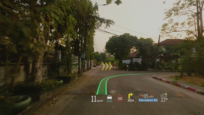
One of the most compelling benefits of AR navigation is the direct visual overlay of directions and information onto the live view of the road or path ahead. Instead of glancing down at a screen, users see arrows, street names, and points of interest (POIs) projected directly onto their view of reality, often through a smartphone screen, a dedicated heads-up display (HUD), or smart glasses. This eliminates the need to constantly switch focus between the road and a separate display, enhancing safety and reducing distraction.
- Dynamic Directional Arrows: Large, clear arrows appear directly on the road, indicating precisely where to turn or which lane to take. This is particularly useful in multi-lane highways or complex intersections.
- POI Identification: As you drive or walk, AR can highlight nearby restaurants, gas stations, landmarks, or stores, displaying their names, ratings, and even opening hours in your field of view. This provides immediate, contextual information without requiring a separate search.
- Traffic and Obstacle Warnings: Advanced AR systems can detect and highlight real-time traffic congestion, road hazards, or even pedestrians, providing visual warnings that are impossible with traditional GPS.
- Building and Landmark Recognition: For pedestrian navigation, AR can identify specific buildings or entrances, making it easier to find your destination in a dense urban environment.
Improved Situational Awareness and Reduced Cognitive Load
By integrating digital information directly into the user's perception of the physical world, AR navigation significantly boosts situational awareness. Drivers can keep their eyes on the road, while pedestrians can remain more aware of their surroundings. This direct integration reduces the cognitive load associated with interpreting abstract map data.
Consider a driver approaching a complex interchange. A traditional GPS might show a spaghetti junction on a 2D map, leaving the driver to figure out which physical lane corresponds to the correct digital line. An AR navigation system, however, would superimpose a glowing path directly onto the correct lane, perhaps even highlighting the specific exit sign. This form of driver assistance is invaluable for reducing stress and preventing missed turns, leading to a smoother and safer journey.
Enhanced Pedestrian and Micro-Mobility Guidance
While often discussed in the context of vehicles, AR's impact on pedestrian navigation is equally profound. Navigating on foot in a new city can be disorienting. AR applications can guide walkers with virtual breadcrumbs, highlight specific building entrances, or even point out historical facts about landmarks as you pass them. For micro-mobility options like scooters or bikes, AR can overlay dedicated bike lanes, safe routes, or even indicate no-parking zones, enhancing both safety and convenience.
Precision and Accuracy Beyond Traditional GPS
While GPS provides a foundational layer of location data, AR navigation systems leverage a sophisticated array of sensors and computational techniques to achieve far greater precision. This is crucial for accurate digital overlays and robust performance in environments where GPS signals might be weak or unavailable (e.g., urban canyons, indoors).
The combination of GPS with Inertial Measurement Units (IMUs), cameras, lidar sensors, and advanced computer vision algorithms allows AR systems to continuously track the user's precise position and orientation in real-time. This precise positioning enables the digital content to be anchored accurately to the physical world, creating a truly immersive and reliable experience. For instance, in complex indoor environments like airports or shopping malls, where GPS is ineffective, AR can provide seamless indoor navigation by mapping surroundings using visual cues.
Key Technologies Powering AR Navigation
The seamless experience of augmented reality navigation is built upon a foundation of sophisticated technologies working in concert.
Computer Vision and SLAM (Simultaneous Localization and Mapping)
At the heart of any robust AR system are computer vision algorithms. These allow devices to "see" and understand the real world. SLAM is a critical component, enabling a device to simultaneously map its environment and track its own location within that map. This means the AR system isn't just relying on GPS coordinates; it's actively understanding the geometry of its surroundings and where it is in relation to known features. This is vital for stable and accurate digital overlays, preventing the "drift" often seen in less sophisticated AR applications. Advanced SLAM techniques contribute directly to robust spatial computing, allowing digital objects to persist realistically in the physical world.
Advanced Sensor Fusion
AR navigation systems don't rely on a single sensor; they intelligently fuse data from multiple sources to create a comprehensive understanding of the user's environment and movement:
- GPS (Global Positioning System): Provides initial global location data.
- IMUs (Inertial Measurement Units): Accelerometers, gyroscopes, and magnetometers track orientation, movement, and direction, compensating for GPS inaccuracies, especially at high speeds or in areas with poor satellite reception.
- Cameras: Essential for computer vision, capturing the visual input of the real world. They identify landmarks, track features, and help with depth perception.
- Lidar (Light Detection and Ranging): Found in more advanced systems (e.g., some smartphones, autonomous vehicles), Lidar creates detailed 3D maps of the environment by emitting pulsed laser light and measuring the time it takes for the light to return. This provides highly accurate depth information.
- Barometers: For accurate altitude tracking, crucial for multi-story buildings or mountainous terrain.
The intelligent fusion of these sensor inputs allows for highly accurate and stable AR experiences, even when individual sensor data might be noisy or incomplete.
Cloud Connectivity and Artificial Intelligence
Modern AR navigation systems are increasingly leveraging cloud computing and artificial intelligence (AI). The cloud provides access to vast databases of map data, points of interest, real-time traffic information, and weather updates. AI algorithms, particularly machine learning, are used to process sensor data, improve object recognition, predict user intent, and optimize routing based on complex factors like traffic patterns, road conditions, and even user preferences. This allows for highly dynamic and personalized navigation experiences that continuously learn and adapt.
Practical Applications Across Industries
The versatility of augmented reality navigation extends far beyond personal vehicles, finding impactful applications across numerous sectors.
Automotive Sector: The Smart Windshield
The automotive industry is a prime beneficiary of AR navigation. Instead of a dashboard screen, future vehicles will increasingly feature heads-up displays (HUDs) that project navigation directions, speed, fuel levels, and even hazard warnings directly onto the windshield. This keeps the driver's eyes focused on the road, minimizing distraction. High-end vehicles are already experimenting with full-windshield AR projections that can highlight lane markings, pedestrian crossings, and even potential collision risks. This elevates vehicle navigation to an entirely new level of safety and intuitiveness.
Imagine driving in heavy fog, and your AR system outlines the road ahead and the vehicle in front of you, even if your natural vision is obscured. Or consider parking assistance that projects precise guidelines onto your parking spot, showing you exactly where to steer. These are not distant dreams but active areas of development for leading automakers.
Mobile Devices and Wearables: Everyday AR Navigation Apps
For most consumers, their first experience with AR navigation will be through their smartphones. Popular mapping applications like Google Maps and Apple Maps already offer basic AR walking directions, using the phone's camera to overlay arrows and street names onto the live view. This makes finding your way in unfamiliar cities significantly easier.
Beyond smartphones, the rise of specialized devices like smart glasses is set to revolutionize personal navigation. Imagine walking down a street and having directions, restaurant recommendations, or even facial recognition of friends displayed discreetly in your field of view, all while keeping your hands free and your attention on your surroundings. These AR navigation apps represent a powerful blend of convenience and immersion for daily use.
Logistics and Delivery: Optimized Routes and Indoor Guidance
In logistics, AR navigation can streamline operations significantly. Delivery drivers can use AR-enabled devices to visualize optimal routes, identify specific delivery points on large campuses, or even locate packages within a warehouse. For complex indoor environments like large factories or distribution centers, AR can provide precise indoor navigation, guiding workers to specific shelves or machinery, improving efficiency and reducing errors. This is particularly valuable for last-mile delivery challenges and complex supply chain management.
Tourism and Urban Exploration: Immersive Experiences
For tourists, AR navigation transforms sightseeing into an interactive adventure. Imagine pointing your phone at a historic building and instantly seeing its name, history, and relevant facts appear as an overlay. AR can guide visitors through museums, highlighting exhibits and providing detailed information, or lead them on interactive city tours that blend historical context with real-time navigation. This creates a deeply immersive experience, enriching travel and exploration.
Challenges and Future Outlook for AR Navigation
While the potential of augmented reality for enhanced navigation is immense, several challenges must be addressed for widespread adoption and seamless integration into daily life.
Overcoming Technical Hurdles
Despite rapid advancements, AR technology still faces technical limitations. These include:
- Latency: The delay between real-world movement and the digital overlay's update can cause motion sickness or a disjointed experience. Minimizing this latency is critical.
- Occlusion: Ensuring digital objects are correctly occluded by real-world objects (e.g., an AR arrow disappearing behind a building) is crucial for realism and usability.
- Power Consumption: Running complex AR applications on mobile devices or wearables can be battery-intensive, limiting usage time.
- Environmental Variability: AR systems must perform reliably in diverse lighting conditions, weather, and environments (e.g., dense fog, heavy rain, bright sunlight).
- Hardware Limitations: The current field of view for most AR devices is still relatively narrow, limiting the amount of information that can be displayed naturally.
User Adoption and Interface Design
Beyond technical performance, user acceptance is paramount. The design of AR navigation interfaces must strike a delicate balance:
- Information Overload: Too much digital information can be distracting, especially for drivers. Interfaces need to be minimalistic, intuitive, and only display truly essential data.
- Safety Concerns: For in-car use, ensuring AR doesn't lead to increased driver distraction is a primary concern. Regulations and best practices for safe AR navigation use are still evolving.
- Comfort and Aesthetics of Wearables: For smart glasses, factors like weight, battery life, style, and social acceptance will dictate widespread adoption.
The Road Ahead: Seamless Integration and Hyper-Personalization
Despite these challenges, the trajectory for AR navigation is unequivocally upward. The future promises even more seamless integration and hyper-personalized experiences. Imagine:
- AR-enabled Autonomous Vehicles: Future self-driving cars could use AR to communicate their intentions to pedestrians or other drivers, displaying their planned turns or stops directly on the road.
- Connected Cities: AR navigation could integrate with smart city infrastructure, providing real-time information about public transport, parking availability, or even air quality data overlaid onto the urban landscape.
- Personalized Guides: AR systems could learn your preferences, suggesting routes based on your interests (e.g., scenic routes, routes with specific types of shops) or even guiding you through a crowd to meet a friend.
- Interoperability: A future where your AR navigation seamlessly transitions from your car's HUD to your smart glasses as you park, and then to your smartphone for indoor guidance, all without interruption.
The convergence of 5G connectivity, more powerful edge computing, and increasingly sophisticated AI will undoubtedly accelerate these developments, making augmented reality navigation an indispensable part of our daily lives.
Actionable Tips for Exploring AR Navigation
For those eager to experience the benefits of AR navigation today or considering its integration into their business:
- For Consumers: Explore Existing Apps: Download and experiment with mainstream mapping apps like Google Maps or Apple Maps that offer AR walking directions. Look for "Live View" or similar features. Also, explore specialized third-party AR navigation apps available on app stores for specific use cases like hiking or urban exploration.
- Prioritize Safety: When using AR navigation on a smartphone while walking, always remain aware of your physical surroundings. For in-car use, if your vehicle doesn't have a dedicated HUD, consider aftermarket HUD solutions that integrate with your phone's navigation, but always prioritize keeping your eyes on the road.
- Stay Informed on Hardware: Keep an eye on advancements in smart glasses and automotive HUDs. As these devices become more affordable and capable, they will offer the most immersive AR navigation experiences.
- For Businesses/Developers: Focus on User Experience: If developing AR navigation solutions, prioritize intuitive interface design, minimal cognitive load, and robust performance in varied environments. Conduct extensive user testing to ensure safety and usability.
- Leverage Sensor Fusion: Do not rely solely on GPS. Integrate data from cameras, IMUs, and other sensors for precise positioning and stable overlays.
- Consider Specific Use Cases: Identify niche areas where AR navigation can provide significant value (e.g., indoor logistics, guided tours, specialized industrial applications) rather than trying to be a general solution.
Embracing augmented reality for navigation is not just about adopting a new technology; it's about embracing a more intuitive, safer, and efficient way to interact with our world. The journey has just begun, and the potential is limitless.
Frequently Asked Questions
What is augmented reality navigation?
Augmented reality (AR) navigation is a technology that overlays digital information, such as directional arrows, points of interest, or street names, directly onto a user's live view of the physical world. Unlike traditional GPS which displays information on a separate 2D map, AR navigation uses a device's camera (e.g., smartphone, smart glasses, or car's windshield HUD) to show you exactly where to go by superimposing virtual cues onto your real surroundings. This creates a highly intuitive and immersive wayfinding experience, reducing the cognitive effort of translating a map to reality. It's often enhanced by real-time data and advanced sensors for precise guidance.
How does AR navigation differ from traditional GPS?
The primary difference lies in how information is presented. Traditional GPS typically shows a 2D map on a screen, requiring the user to interpret abstract symbols and translate them to their physical environment. AR navigation, on the other hand, directly integrates digital guidance into the user's line of sight of the real world. For example, instead of seeing a blue line on a map, an AR system projects a glowing arrow directly onto the road you need to turn on. This direct visual guidance reduces cognitive load, enhances situational awareness, and offers a more natural and intuitive way to navigate. It leverages more than just GPS, often combining it with computer vision, IMUs, and other sensors for superior precise positioning.
Is AR navigation safe to use while driving?
The safety of AR navigation while driving is a critical consideration and depends heavily on its implementation. AR systems that project information onto a car's windshield (heads-up displays - HUDs) are generally considered safer than looking down at a smartphone screen, as they keep the driver's eyes on the road. However, an overly cluttered or distracting AR interface, regardless of the display method, can still pose a risk. Reputable automotive manufacturers and app developers prioritize minimalist design and essential information to avoid distraction. As with any navigation tool, drivers should use AR navigation responsibly, remaining fully attentive to their surroundings and adhering to traffic laws. The goal of AR in this context is to provide better driver assistance, not to replace vigilance.
What are some practical applications of AR navigation today?
Today, you can experience AR navigation through various applications:
- Smartphone AR Walking Directions: Many popular mapping apps (e.g., Google Maps "Live View," Apple Maps "Look Around") offer AR features for pedestrian navigation, overlaying arrows and street names onto your phone's camera view.
- Automotive HUDs: Some high-end vehicles integrate AR-like features into their windshield HUDs, showing speed, navigation arrows, and collision warnings directly in the driver's line of sight.
- Industrial and Logistics: AR is used in warehouses and factories for guiding workers to specific inventory locations or optimizing delivery routes with visual overlays.
- Tourism and Education: AR apps provide interactive city tours, overlaying historical information onto landmarks, or guiding visitors through complex museum layouts.
These applications demonstrate the diverse and growing utility of augmented reality for enhanced navigation systems.

0 Komentar